
Geography
National
Level of Effort
High
Overview
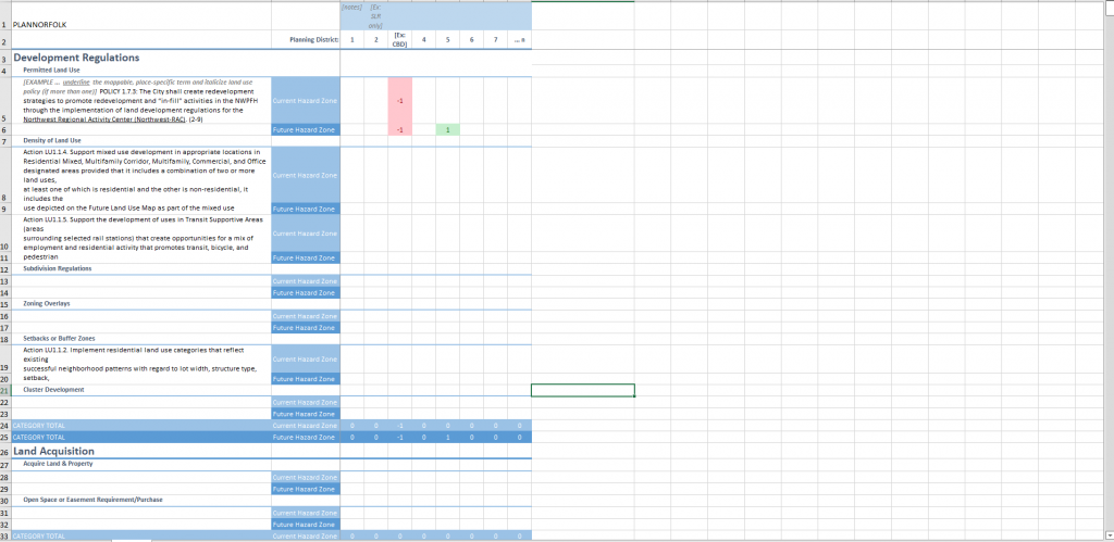
This tool provides a method for understanding and assessing the consistency of local plans through spatial analysis as a way to improve community resilience.
Features
- Identify conflicts within and among planning documents
- Systematically assess policies within plans
- Understand the spatial distribution of policies and their impacts
- Prioritize and strategize future plan updates and policy and program changes
- Make simple adjustments to existing policies and plans, embedding and weaving resiliency principles through existing processes and efforts
- Reduce hazard vulnerability at the neighborhood level
- Implement resiliency measures equitably across neighborhoods and geographies
- Track policy implementation status, measure success, or ensure accountability over time
Guidance & Resources
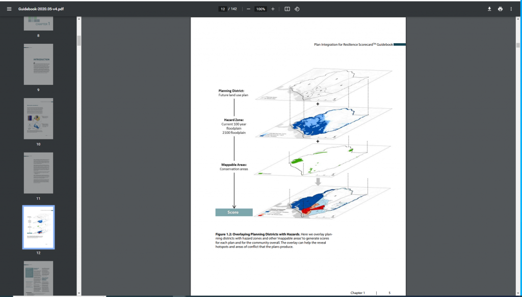
Planners and communities can use the PIRS guidebook and scorecard to evaluate community plans with respect to hazards risk and how well they target areas of the community that are most vulnerable, identify when and where those plans are in conflict, and resolve those conflicts across plans to reduce hazards vulnerabilities. The scorecard is not meant to be used in isolation. It can and should be integrated with broader community initiatives, such as historic preservation, environmental conservation, and disaster recovery planning.
Tool Custodian & Partners
Related Data & Tools
- Texas A&M University
- University of North Carolina-Chapel Hill
Publications
- Berke, P., Kates, J., Malecha, M., Masterson, J., Shea, P., & Yu, S. (2021). Using a resilience scorecard to improve local planning for vulnerability to hazards and climate change: An application in two cities. Cities, 119, 103408. DOI:10.1016/j.cities.2021.103408.
- Yu, S., Malecha, M., & Berke, P. (2021). Examining factors influencing plan integration for community resilience in six US coastal cities using Hierarchical Linear Modeling. Landscape and Urban Planning, 215, 104224. DOI:10.1016/j.landurbplan.2021.104224.
- Malecha, M. L., Woodruff, S. C., & Berke, P. R. (2021). Planning to Exacerbate Flooding: Evaluating a Houston, Texas, Network of Plans in Place during Hurricane Harvey Using a Plan Integration for Resilience Scorecard. Natural Hazards Review, 22(4), 04021030. DOI:10.1061/(ASCE)NH.1527-6996.0000470.
- Yu, S., Brand, A.D., Berke, P. (2020). Making Room for the River: Applying a Plan Integration for Resilience Scorecard to a Network of Plans in Nijmegen, Netherlands. Journal of the American Planning Association, 86(4), 417-430. DOI:10.1080/01944363.2020.1752776.
- Berke, P., Yu, S., Malecha, M., & Cooper, J. (2019). Plans that disrupt development: Equity policies and social vulnerability in six coastal cities. Journal of Planning Education and Research. DOI:10.1177/0739456X19861144.
- Newman, G., Malecha, M., Yu, S., Qiao, Z., Horney, J., Lee, J., Kim, Y.J., Lee, R.J., & Berke, P. (2019). Integrating a resilience scorecard and landscape performance tools into a geodesign process. Landscape Research. DOI:10.1080/01426397.2019.1569219.
- Malecha, M.L., Brand, A.D., & Berke, P.R. (2018). Spatially evaluating a network of plans and flood vulnerability using a Plan Integration for Resilience Scorecard: A case study in Feijenoord District, Rotterdam, the Netherlands. Land Use Policy, 78, 147-157. DOI:10.1016/j.landusepol.2018.06.029.
- Berke, P.R., Malecha, M.L., Yu, S., Lee, J., & Masterson, J.H. (2018). Plan Integration for Resilience Scorecard: Evaluating networks of plans in six US coastal cities. Journal of Environmental Planning and Management. DOI:10.1080/09640568.2018.1453354.
- Berke, P., Newman, G., Lee, J., Combs, T., Kolosna, C., & Salvesen, D. (2015). Evaluation of networks of plans and vulnerability to hazards and climate change: a resilience scorecard. Journal of the American Planning Association 81(4), 287–302. DOI:10.1080/01944363.2015.1093954.
Tags
PIRs, resilience, planning, plan evaluation, climate adaptation, resilience scorecard, plan integration